4th of July Party Ideas!

Quickie Garland

08-fourth-of-july-garland-fslTo make your own 4th of July party garland on the cheap, try this trick from Fun Home Things, who cut red, white, and blue plastic tablecloths into strips, and tied them to a set of string lights.

Independence Punch


05-fourth-of-july-punch-fsl
A drinkable 4th of July flag! Big Bear’s Wife mixed up a patriotic beverage using cranberry juice, blue Gatorade Frost, Diet 7-Up, and ice cubes for a refreshing party cooler.

Flag Canopy


13-fourth-of-july-streamers-fsl

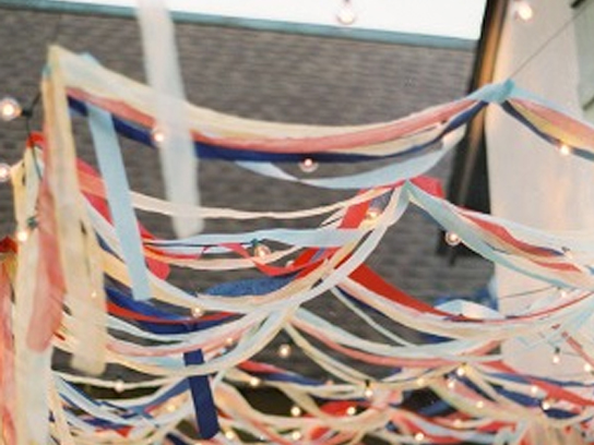
Create a classy canopy and mood lighting for your 4th of July party with this genius idea from Style Me Pretty. Tie red, white, and blue paper streamers onto big-bulb outdoor lights, and hang above a picnic table or a grassy dance space.

Muffin Tin Art Caddy


12-fourth-of-july-muffin-tin-fsl1.jpg

Vaccuming in High Heels & Pearls created this quick DIY with a muffin tin and some red, white, and blue buttons, beads, and other odds and ends. For a 4th of July party activity, leave it out on a backyard table for kids to string necklaces and bracelets.

Everlasting Snow Cones14-fourth-of-july-snow-cones-fsl

Make snow cones that won’t melt—these beauties are actually Bakerella cupcakes in disguise. A glittery tri-color frosting tops a layered three-color cake that you (and your party guests) have got to see to believe.

Firework Rings

07-fourth-of-july-rings-fsl

Make fun fireworks accessories with the kids using this tutorial from Fantastic Fun and Learning. Twist together sparkly tinsel stems (or patriotic-color pipe cleaners) to create cute rings.
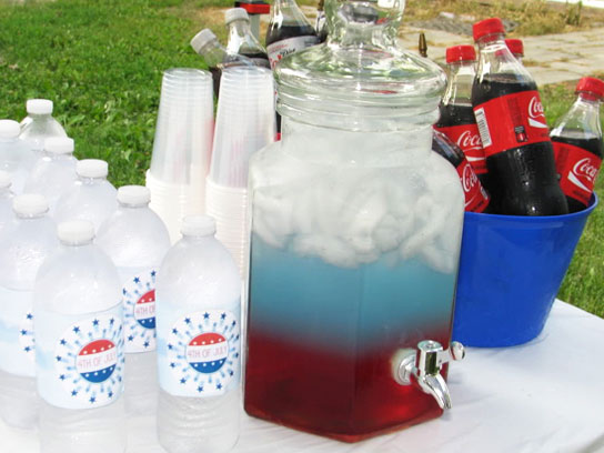
Cool Soda Bar

04-fourth-of-july-ice-cream-fsl

Desserts on the 4th of July can be used as party decorations with this sweet soda bar idea from Let’s Dish. Group red, blue, and clear soda bottles on a table with small bowls of striped straws, cherries, sprinkles. After the grill is off, bring out ice cream and let guests make their own ice-cream floats.

Have a safe 4th of July weekend! 

source

The Montclair Neighborhood

The connection between the infamous “Red Baron” of World War I and the Montclair neighborhood can be found in Baron Manfred von Richthofen- he was the uncle of the “Red Baron” and the father of Montclair! Richthofen arrived in Colorado from Germany in 1877. A man of many interests, he started the Downtown Denver Real Estate Company in 1881, was novelist, and was also the founding member of the Denver Chamber of Commerce. With Matthias P. Cochrane, Richtofen established the Montclair Town and Improvement Company in 1885. Though promoted as a healthy place to live, away from the smoke and fumes of the city, the Montclair neighborhood was not drawing residents. To demonstrate the wonderful quality of life there, the Baron decided to build a castle of his own at 12th and Olive. He had the Montclair ditch created, which was was a lateral of the Highline canal, eventually flowing into Montcalir Park. The water supple enabled many flowers, trees, and shrubs to be planted and to thrive where the land had previously been essentially barren. In 1890, the Baron platted his own addition to Montclair and the building continued. With the Colorado Women’s College (1980) and the Fairmount Cemetery (1980), as well as the increasingly well-known reputation as a community for people suffering from lung-related illnesses, Montclair thrived. It was also home to the National Jewish Hospital and Agnes Memorial Sanatorium, one of the largest tuberculosis treatment centers in Colorado.

Untitled
Map of Montclair
SONY DSC
Montclair Park

Parks

Montclair Park

Denison Park


Area Information

To Downtown………… 23 min

To Cherry Creek Mall… 13 min

To I-25………….………… 17 min

Grocery Store………. Safeway


Walk Score: 56   Bike Score: 73

The Mayfair (Hale) Neighborhood

Nestled between some of Denver’s most sought after neighborhoods, Mayfair is a small community of friends and neighbors residing in a collection of tudors, bungalows, and ranches a short distance east of Downtown Denver. In 1885, Baron Walter Von Richthofen proclaimed Mayfair “The Beautiful Suburban Town of Denver” and advertised the area as a healthy alternative to the moral dilemmas of city living. The area now known as Mayfair became part of Denver in 1902 but was not officially named until after World War II when returning GI’s settled in the area. The area was attractive to these men and their families for many of the same reasons that Mayfair is so popular today. With its wide streets, large lots, varied architecture, and proximity to Downtown Denver, Mayfair is truly an example of urban living with a suburban feel.

City Park is located just north of Mayfair near the Denver Zoo and the Museum of Nature and Science. Mayfair has its own shopping center at 14th and Krameria Street which has been serving the community for over fifty years, while Colfax Avenue boasts its own assortment of shops and restaurants on the northern border of the neighborhood. In addition, Mayfair is just up the street from the shops, restaurants, and special events found in Cherry Creek.

map
Map of Mayfair
glencoe exterior photo
House in Mayfair

Parks

Mayfair Park

Lindsley Park


Area Information

To Downtown………… 12 min

To Cherry Creek Mall… 7 min

To I-25………….………… 17 min

Grocery Store………. Marczyk Fine


Walk Score: 66   Bike Score: 82

The Lowry Neighborhood

A planned mixed-usage area with distinct boundaries, the Lowry neighborhood has garnered awards and plenty of attention since it broke ground in 1996. With retail, education and recreation opportunities, corporate and residential real estate, plus parks and open space all within its three square miles, Lowry is a complete community. The centralized East Denver-West Aurora location is an easy commute to all points in the metro area. Its borders are defined by the previous, gated venue: Lowry Air Force Base. Hangers No. 1 and 2 remain as part of Wings Over the Rockies Aviation & Science Museum, where military planes are displayed indoors and out. Officers’ quarters were transformed into distinctive duplexes; other government housing and buildings were turning into lofts, apartments, and business offices.

New construction includes an impressive parkway of million-dollar mansions on Sixth Avenue. Lowry’s final completion date in 2011 includes a total of 4,600 homes and apartments with around 10,000 residents. A mix of private, charter schools, and those under the jurisdiction of Denver Public Schools cover pre-kindergarten ages to post high school with a small community college campus. Almost 30 percent of the neighborhood is dedicated to parks, trails, wetlands and open space.

lowry map
Map of Lowry
LowryBeerGarden.0
Lowry Beer Garden

Parks

Kittredge Park

Great Lawn Park


Area Information

To Downtown………… 25 min

To Cherry Creek Mall… 17 min

To I-25………….………… 18 min

Grocery Store………. Safeway


Walk Score: 66   Bike Score: 73


The LoDo Neighborhood

The Lower Downtown area was the site of the original settlement that began when people came to the region in the 19th century in search of gold. The LoDo neighborhood is one of the best examples of urban redevelopment in Denver. The lower downtown area today is one of the busiest and most exciting neighborhoods in the region. Downtown Denver is full of shops, art galleries, and restaurants, but it also has a selection of residential properties, predominantly stylish lofts and luxurious apartments.

LoDo is a hub of cultural events and entertainment in the city. Attractions within the LoDo area include Denver’s Museum of Contemporary Art, the Children’s Museum of Denver, 16th Street Mall and Elich Gardens. It is also the location of two of the major sporting venues in the city: Coors Fields and the Pepsi Center arena.

The 16th street mall promenade runs for the length of 16 blocks, with shops, boutiques, restaurants, and outdoor cafes along either side. The huge Tabor Center mall lies along this street, as does the Denver Pavilions, which the perfect place to see a movie on an evening out.

Untitled lodo map
Map of LoDo
lodotour25
LoDo

Parks

Commons Park

River Front Park

Confluence Park


Area Information

To Downtown………… 5 min

To 16th Street Mall… 5 min

To I-25………….………… 10 min

Grocery Store………. Natural Grocers


Walk Score: 94   Bike Score: 86